Trail On foot San Venanzo - Anello Elmo - Photo

Tous les sentiers balisés d’Europe PRO

© OpenStreetMap contributors
Length
Length
7.9 km
Max alt
Max alt
534 m
Uphill gradient
Uphill gradient
417 m
Km-Effort
Km-Effort  
13.5 km
Min alt
Min alt
185 m
Downhill gradient
Downhill gradient
421 m
Boucle
Boucle
Yes
Signpost
Signpost
Creation date :
2022-02-15 15:49:23.913
Updated on :
2022-03-01 16:35:37.703

(0 Reviews)

On foot
On foot
3h03
Difficulty : Easy

Scan this QR Code to open this trail in the SityTrail application

FREE GPS app for hiking

Logo SityTrail SityTrail

IGN / Geographical institutes

Download SityTrail from the App Store Download SityTrail from Google Play

Logo SityTrail SityTrail World

The world is yours!

Download SityTrail from the App Store Download SityTrail from Google Play Download SityTrail on Huawei AppGallery

About

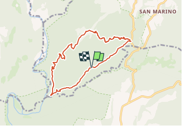
Trail On foot of 7.9 km to be discovered at Umbria, Terni, San Venanzo. This trail is proposed by SityTrail - itinéraires balisés pédestres.

Description

Trail created by Sistema Territoriale di Interesse Naturalistico Ambientale (S.T.I.N.A.).

Photos

Positioning

Country:
Italy
Region :
Umbria
Department/Province :
Terni
Municipality :
San Venanzo
Location:
Unknown
Start:(UTM)
266677 ; 4743652 (33T) N.

Trails nearby

Trail On foot Allerona - Anello orvietano - Photo
On foot
PRO

On foot

Very difficult
Allerona, Umbria, Terni, Italy
178 km | 249 km-effort
56h 34min
Yes
Trail On foot Allerona - Anello Villa Cahen - Photo
On foot
PRO

On foot

Easy
Allerona, Umbria, Terni, Italy
9.7 km | 13.8 km-effort
3h 7min
Yes
Trail On foot Marsciano - Migliano - Fersinone - Fibbino - Photo
On foot
PRO

On foot

Easy
Marsciano, Umbria, Perugia, Italy
13.4 km | 19.1 km-effort
4h 20min
Yes
Trail On foot Marsciano - Compignano - Monte Lagello - Mercatello - Photo
On foot
PRO

On foot

Easy
Marsciano, Umbria, Perugia, Italy
10.8 km | 14.8 km-effort
3h 21min
Yes
Trail On foot Città della Pieve - Città della Pieve - Fosso Molinella - Photo
On foot
PRO

On foot

Easy
Città della Pieve, Umbria, Perugia, Italy
7 km | 10 km-effort
2h 16min
Yes
Trail On foot Piegaro - Montarale - Greppolischieto - Photo
On foot
PRO

On foot

Easy
Piegaro, Umbria, Perugia, Italy
11.4 km | 17.5 km-effort
3h 58min
Yes
Trail On foot Baschi - Baschi - Civitella del Lago - Salveregina - Photo
On foot
PRO

On foot

Medium
Baschi, Umbria, Terni, Italy
16.3 km | 24 km-effort
5h 30min
No
Trail On foot Montecchio - Anello di Civitella del Lago - Photo
On foot
PRO

On foot

Difficult
Montecchio, Umbria, Terni, Italy
19.9 km | 33 km-effort
7h 27min
Yes
Trail On foot Baschi - Anello Baschi - Diga di Corbara - Photo
On foot
PRO

On foot

Easy
Baschi, Umbria, Terni, Italy
10.5 km | 13.9 km-effort
3h 9min
Yes


Close
My subscriptions